Trace Ridge Trail

At A Glance


3.1 mi one-way
Difficulty Rating: 3.1 ![]()
Steepness: Climbs Steeply ![]()
Tread Condition: Some Obstacles ![]()
Blaze Color: Orange
Trail Number: 354
Rides That Use This Trail: Fletcher Creek
Description
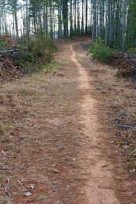
Uphill from the Trace Ridge trailhead parking lot, this trail follows an old roadbed to the parkway. It is a rocky trail: either a fast, bumpy downhill, or a steep, technical uphill. Highly recommended!
Downhill from the trailhead, this trail was formerly a steep, damaged mess due to erosion - in places, it was a waist deep, clay canyon. As of October 2015, however, the trail has been re-routed and is now a sustainable, fast, flowy trail on a gentle grade, adding a good bit more distance to the trail in addition to solving the erosion issues. There are a few roots and rocks left to spice it up a bit, although it'd be a stretch to call it technical. This stretch is also now highly recommended!
Intersecting Trails
This trail is located in the Mills River area. For a list of all the trails in that area, see the Mills River trails list page.
This trail also crosses into these trailhead areas:
All Photos from the Trail


GPS Map
Map Information
Download GPS Data
Click on a route, trail, or point on the map and select the GPS Data tab to download its data.
Data Formats
KML (Google Earth)
KML is the main file type used by Google Earth. If you have Google Earth installed, clicking the KML link should open the trail or point directly in Google Earth for viewing. This is the native file format used by Google Earth, but many other map applications can use and understand KML as well, so if you're not sure which one to download, KML is a good bet.
GPX
The GPX format stands for GPS Exchange - a free, open, XML format for exchanging GPS and map data. GPX is compatible with Google Earth, many other mapping programs, and most GPS devices (such as Garmin). Load the file directly into your GPS to help find your way on your next trip!
GeoJSON
GeoJSON is a newer, lightweight data exchange format which can be used to quickly share map data and may have a smaller size than KML or GPX. Many professional mapping and GIS applications support the GeoJSON format.
About the Map
Copyright
Base Layers
Base layers provided by OpenStreetMap, the US Geological Survey, the US Forest Service, and NC OneMap. Base layer images are subject to the respective copyright policies of their owners. Base layers may not be available at all times due to system maintenance or outages.
WNCOutdoors Base Layer
The WNCOutdoors Base layer is provided by WNCOutdoors.info. It is licensed by Creative Commons Attribution 3.0.
Trail and Marker Overlays
Trail layers and downloadable data are all original works created by WNCOutdoors with guidance from a variety of sources, including ensembles of our own GPS tracks, user contributed GPS tracks, official maps and GIS data from government agencies, and field observations. WNCOutdoors data is made freely available under the Open Database License - you are free to copy and use it for any purpose under the terms of that license (summary).
Tips
- Hover over a trail to see it highlighted. Helps to see start and end points for an individual trail.
- Scroll and zoom the map before printing, and that view will persist into the printed image.
- Click a trail for more details and to download it individually.
Trail Segments
Trails are often made up of several connecting paths which may have different characteristics, allowed uses, and seasons. This trail is divided into multiple segments as follows:
Spencer Gap to Blue Ridge Parkway
- Allowed Uses: Hiking
- Length: 0.34 mi
Trailhead Parking to Spencer Gap
- Allowed Uses: Hiking, Mountain Biking, Horseback Riding
- Length: 2.69 mi
Trailhead Parking to Wash Creek Trail
- Allowed Uses: Hiking, Mountain Biking, Horseback Riding
- Length: 0.57 mi
Wash Creek Trail to N. Mills River Trail
- Allowed Uses: Hiking, Mountain Biking, Horseback Riding
- Length: 0.73 mi
Total Calculated Length: 4.32 mi
This value is derived from our underlying map data, and it may not match officially published information.
Feedback
Ratings
Average Rating: 3.0 (rated 1 times)
Rate It Now:

Damon said: Just rode this trail today 11/27/16 from the Parkway down to the campground. The upper section is deeply (sometimes chest deep!) rutted out, but still rideable with some finesse. It's gets better as you go down though. Section past the parking area/trailhead is varied terrain/full of switchbacks and a lot of fun.
molly said: Just rode this trail in late February 2016 and it seems to have been badly eroded again since the work that was done on it last year- definitely back to a waist deep clay canyon in places.